
Photo: Gerd Eichmann / Wikimedia Commons (CC BY-SA 4.0)
Lanna and France: 1893 and the Mekong
Lanna and France is the story of a river. Before 1893 the Mekong was a road that people on both banks crossed all the time, and Nan had dependent towns on both sides. Within little more than ten years, a series of treaties between Siam and France turned the river into an international border that is still in use today. This article is part of the Lanna and the World series. It looks at how that line was drawn, and where it touched Lanna.
Kham Mueang has just the word for it: mai lak (mai lak, หมฯายฯหัลฯก), which the dictionary explains as "to plant posts to mark a boundary". In these years, boundary commissions from both sides walked the land, made maps and set real boundary posts on ridges and riverbanks.
The land at the edge of a domain is khok mueang (khok mueang, ขอฯกเมิอฯง), "the border zone of a town". River towns such as Chiang Saen, Chiang Khong and Nan's Muang Ngoen were the khok mueang where this story happened, and what the treaties tried to fix was the daen (daen, แดนฯ), which the dictionary defines as "a territory that is set, or clearly divided off".
- Years are in CE; the Thai version also gives the Buddhist Era year in today's count (B.E. = CE + 543). Siam then began its year on 1 April, so old Thai documents may give a January–March event one year earlier (see Common misunderstandings).
- Left bank and right bank follow the direction of the current. The Mekong flows north to south, so broadly the left bank is the Lao side and the right bank the Thai side.
- Lines on the map are approximate. We shade only areas whose extent the sources state, and every step names its sources.
- Britain, teak and the Chiang Mai treaties belong to another part of this series; this one tells the eastern side.
Before the border: the Mekong of Nan, Lan Xang and the Tai Lue
Before the treaties, land along the Mekong was not divided by lines on a map but by ties between towns. Small towns were bound to larger ones, and some to several at once. The east bank was the land of Lan Xang (Lan Jang, ล้านฯช้างฯ), which the dictionary explains as "the kingdom of the Lao people, in the Mekong basin", with Luang Prabang as its capital. In the 19th century Luang Prabang was a kingdom under Siam.
On the Lanna side, the town nearest the Mekong was Nan (Mueang Nan, เมิอฯงนาฯ่นฯ). A 2013 Chiang Mai University thesis by Mari Sakamoto, citing the historians Saraswadee Ongsakul and Rattanaporn Sethakul, says that after Nan was restored in the early Bangkok period its rulers re-founded Chiang Khong and Thoeng. Nan's land reached the Mekong at Chiang Khong in the north and ran down the river in the east to Chiang Lom, Chiang Hon and Muang Ngoen, and towns on the left bank such as Muang Sing, Luang Namtha and Chiang Khaeng were counted as its dependencies.
The same work cites Saraswadee for the older idea that the right bank of the Mekong was Lanna's sphere and the river a natural border between Lanna and Lan Xang, a principle still followed into the late 19th century; palm-leaf and folded-paper manuscripts place Muang Ngoen under Nan.
The people of the river did not follow lines either. The Tai Lue (jao tai lue, ชาวฯไทลื้), whom the dictionary describes as coming from Sipsong Panna, lived in Muang Ngoen, Chiang Khong and Nan. The Khmu (khamu, ขหุ), the dictionary says, live in large numbers both in Luang Prabang province and in Nan. Both peoples still live on both banks today.
France comes up the Mekong (1866–1887)
France entered the region from the south: Cochinchina became a colony and, in 1863, Cambodia a French protectorate. France then wanted to know whether the Mekong could carry trade to China. In 1866–68 the French Mekong expedition led by Doudart de Lagrée and Francis Garnier travelled up the river, passing Luang Prabang in 1867 and going on into Yunnan. Britannica records that the party mapped land unknown to Europeans and made the first European entry into Yunnan from the south.
Twenty years later, in 1886, France sent Auguste Pavie to Luang Prabang as vice-consul. Britannica says Pavie spent years touring northern Laos and winning over local rulers. In 1887, after the Siamese army withdrew, an armed band from the east overran Luang Prabang, and Pavie helped King Oun Kham escape. That same year France joined Cochinchina, Annam, Tonkin and Cambodia into the Indochinese Union.
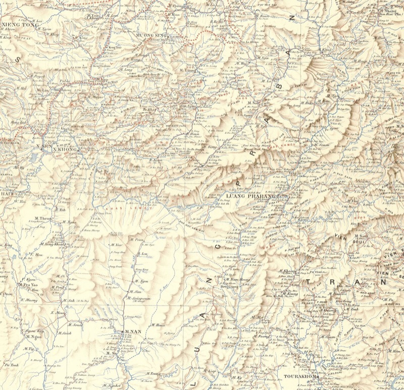
Image: Pavie Mission and Poulmaire (engraver) / Bibliothèque nationale de France via Wikimedia Commons (public domain), cropped by Moradok Lanna
Siam was reorganising too: in 1892 it grouped the Lanna towns as "Monthon Lao Chiang", as told in Lanna: the name and 700 years.
The crisis of 1893 (R.S. 112)
The quarrel over the left bank came to a head in the summer of 1893. On 13 July French warships forced their way past Paknam at the mouth of the Chao Phraya, exchanging fire with the forts, and anchored at Bangkok. Tanapong (2023) describes a tense night at the Siamese court, which chose diplomacy over war and announced that the Paknam clash had been a "misunderstanding".
On 20 July France gave a 48-hour ultimatum, first demanding that Siam give up all claim to the left bank and the islands. Siam accepted on 29 July, but the next day France added more demands: to hold Chanthaburi for the time being, no Siamese troops within 25 km of the right bank, no armed boats on the Great Lake of Cambodia, and the right to place consuls at Nan and Khorat.
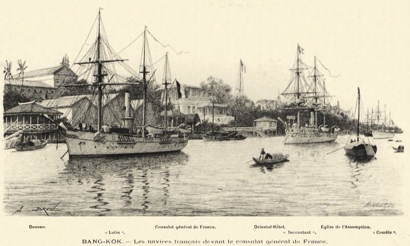
Image: Michelet after Alexandre Jean-Baptiste Brun / Wikimedia Commons (public domain)
The treaty was signed in Bangkok on 3 October 1893. The text the US legation in Bangkok sent to Washington and the US State Department's Laos–Thailand boundary study (International Boundary Study No. 20) agree on its core.
| Article | What it says | Where Lanna comes in |
|---|---|---|
| I | Siam renounces all claim to the left bank of the Mekong and the islands in the river | The banks opposite Chiang Saen and Chiang Khong, and the left-bank towns once under Nan, go to the French side |
| III | No fortified posts or military establishments in Battambang, Siem Reap or within 25 km of the right bank | Chiang Saen, Chiang Khong and Nan's Muang Ngoen lie inside this zone |
| VIII | France may place consuls where it sees fit, "particularly at Korat and Muang Nan" | Nan is named in the treaty |
The legation's cover letter also records that France occupied Chanthaburi as a guarantee. We have not found enough evidence of when, or whether, a French consulate actually opened at Nan, so we can only say that the treaty allowed it.
Step through the treaties yourself on the map below, from 1887 to today. Each town's dot shows which side it was on at each step; tap 🔍 to zoom in on Lanna and Nan, and try the "Which side?" game at the end of the widget.
Muang Sing and the 1896 declaration: where the Golden Triangle began
The 1893 treaty left a problem on the upper Mekong. Above Chiang Saen, the left bank was Chiang Khaeng, with its capital at Muang Sing. Britain, which had taken all of Burma in 1885, claimed the Shan side; France claimed the left bank under the treaty. Britain proposed a "buffer state" between them, but the talks dragged on.
Chandran Jeshurun (1970), writing in the Journal of the Siam Society from British Foreign Office files, says that on 21 March 1895 British India sent 130 Gurkha troops across the Mekong to Muang Sing, as a bargaining chip to bring France to terms over Siam's future.
The result was the Anglo-French declaration of 15 January 1896, which, Jeshurun notes, was negotiated in London and Paris without reference to the Siamese government. It made the deep channel of the Mekong, from the mouth of the Ruak (the "Nam Huok" of the declaration) north to the Chinese border, the dividing line between British and French possessions, and both powers agreed not to occupy the Chao Phraya basin. Muang Sing, on the left bank, fell on the French side. The US Burma–Laos boundary study (No. 33) confirms that this stretch of the Mekong is still the Burma–Laos border.
The point where the Ruak meets the Mekong is Sop Ruak (sop luak, ส฿ปฯรวฯก), in Chiang Saen district of Chiang Rai (Jiang Hai, ชยฯงรายฯ). The 1896 declaration made it the meeting point of three countries, known today as the Golden Triangle. More on Chiang Saen and the Tai Lue of Chiang Khong in Chiang Rai (Jiang Hai).
1904: a border beside Nan
The next question was the right bank opposite Luang Prabang, land in which both Nan and Luang Prabang had a stake. Sakamoto (2013), citing Saraswadee Ongsakul and Rattanaporn Sethakul, lists the right-bank towns under Nan as Muang Ngoen, Muang Khop, Chiang Lom and Chiang Hon; under the Local Administration Act of R.S. 116 the four were grouped as "Khwaeng Hua Khong", with its office at Chiang Lom.
One reason both sides wanted this land, in Saraswadee's account as cited by Sakamoto, was the salt wells (bo kuea, บอฯเกิลฯอฯอ) found in numbers around the headwaters of the Nan River, and Muang Ngoen itself lay inside the 25 km zone of 1893. Most people in Muang Ngoen were loyal to Nan's ruler, who sent his son Nan Sutthisan to govern it, but Luang Prabang also sent soldiers and officials.
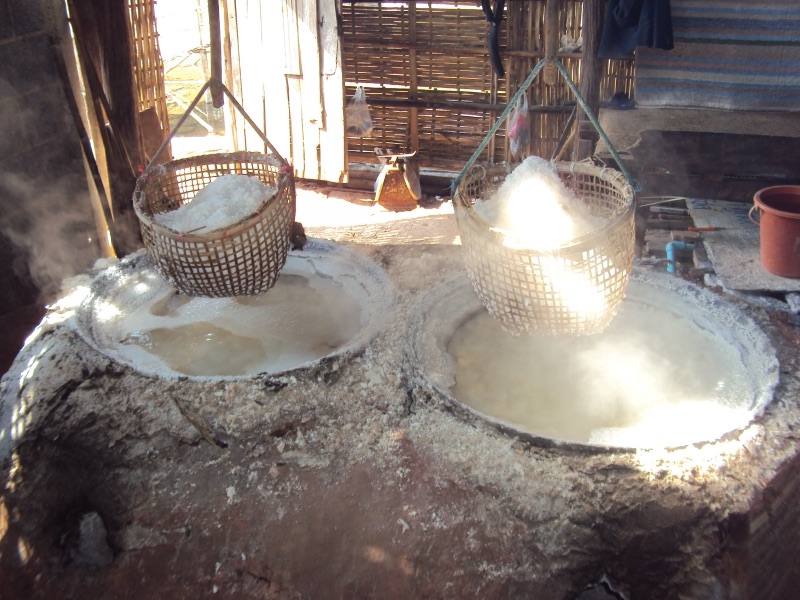
Image: Tankura / Wikimedia Commons (CC BY 3.0)
The matter was settled by the Siam–France convention signed in Paris on 13 February 1904. Article II drew the line "between Luang Prabang, on the right bank, and the provinces of Muang Pichai and Muang Nan": from the mouth of the Nam Heuang on the Mekong, up the Nam Heuang and the Nam Tang to the watershed between the Mekong and Chao Phraya basins, north along that watershed to the source of the Nam Kop, and down the Nam Kop to the Mekong. A protocol that June moved the southern part to follow the Nam Heuang instead of the Nam Tang. The US Cambodia–Thailand boundary study (No. 40) sums up the land ceded as today's Xaignabouli (Sayaboury) province of Laos.
Sakamoto writes that Siam gave up Muang Ngoen and the other right-bank towns in exchange for France ending its occupation of Chanthaburi. The US minister's report of 1905 sums up both sides: France gained Luang Prabang's right bank, Bassac (Champasak) and Melouprey further south, and Trat; Siam regained Chanthaburi, saw the 25 km zone abolished and settled the question of French protégés. The last French soldier left Chanthaburi on 9 January 1905.
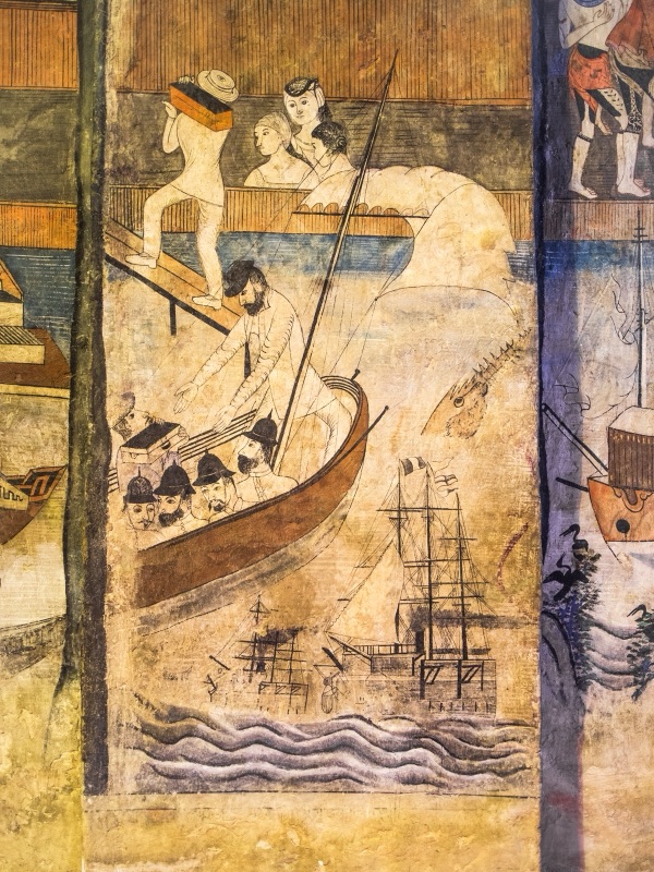
Image: Takeaway / Wikimedia Commons (CC BY-SA 4.0)
More on Nan, Wat Phumin and the salt wells in Nan: a small city of many peoples.
1907: Battambang, Siem Reap and the protégés
The next treaty was signed in Bangkok on 23 March 1907. According to Lawrence Palmer Briggs (1946) and boundary study No. 40, Siam ceded Battambang, Sisophon and Siem Reap to France (art. I) in return for Trat and Dan Sai (art. II), both given up under the 1904 protocols.
Just as important as land were France's Asian subjects and protégés. Many people from the lands of French Indochina living in Siam had registered as French protégés and so did not come under the ordinary Siamese courts; Briggs cites a French writer's estimate of about 18,500 in 1907. Under the 1907 treaty, those registered after its date came under the regular Siamese courts. In the north, beside Nan, the Laos–Siam line stayed as agreed in 1904.
For Lanna these treaties were changes far to the south. Yet in the same years the Lanna towns themselves went from tributary states to "Monthon Phayap", in 1899, as told in Lanna: the name and 700 years. Both were lines being drawn on the same land, from different sides.
Afterwards: river islands, 1941 and 1946
The 1893 treaty gave every island in the Mekong to France, which raised the question of where in the river the line ran. The convention of 25 August 1926 answered: where there are no islands, along the deep channel; where there are, along the deep channel of the branch nearest the Siamese bank (ta fang, ตาฝั่งฯ). The islands therefore lie on the Lao side, except a few named ones attached to Siam. Boundary study No. 20 notes that in the dry season parts of this line become almost a land border.
In 1940–41 Thailand and French Indochina fought, Japan mediated, and the Tokyo convention of 9 May 1941 returned to Thailand the Lao lands west of the Mekong and the Cambodian lands ceded in 1907. Sakamoto records that Thailand created four new provinces, Lan Chang (Xaignabouli), Champasak, Phibunsongkhram and Battambang; elderly Tai Lue in Muang Ngoen interviewed for her research remembered learning to read Thai from Thai teachers at the time.
After the war, the Washington settlement of 17 November 1946 annulled the Tokyo convention and put the 1893, 1904, 1907 and 1925 treaties back in force with their lines. Today's Laos–Thailand and Cambodia–Thailand borders are those lines. Japan in northern Thailand during the war belongs to another part of the Lanna and the World series.
France and knowledge of Lanna
The French connection was not only about borders; French translations also brought Lanna texts to the world. Camille Notton joined the French legation in Bangkok in 1906 and was French consul in Chiang Mai from the First World War until the Second, according to François Lagirarde (2002). Notton translated the Chiang Mai Chronicle from Tai Tham script into French; it was printed in Paris in 1932 as volume III of the Annales du Siam, and the archives of the École française d'Extrême-Orient (EFEO) still hold a typescript of his translation. More in The Chiang Mai Chronicle and Mangraisat.
Earlier, in 1925, the French scholar George Cœdès translated the Jinakalamali into French with the Pali text; see Jinakalamali. Works like these brought Lanna to mueang nok (mueang nok, เมิอฯงนอฯก), "foreign countries", as a land with chronicles, laws and histories of its own.
The Mekong today
Today the Laos–Thailand border starts at Sop Ruak and follows the Mekong for about 95 km past Chiang Saen and Chiang Khong, then leaves the river along ridges and the Nam Heuang east of Chiang Rai, Phayao and Nan, before returning to the Mekong for about 870 km more, by the figures of boundary study No. 20. Across from Chiang Khong lies the town of Huay Xai in Bokeo province, Laos.
The river still feeds both banks. The dictionary says the giant catfish (pa buek, ปลฯาบึกฯ) "lives only in the Mekong and its tributaries", and kai (kai, ไค), a fine green river weed, is "found in the Mekong and the Nan River". Neither fish nor weed knows the border, and Tai Lue, Khmu and Khon Mueang people still live on both banks.
Common misunderstandings: what the sources show
"Lanna lost its land to France all at once in 1893"
The sources show several steps. 1893 covered the whole left bank, including the left-bank towns once under Nan. Nan's right-bank towns, Muang Ngoen, Chiang Hon and Chiang Lom, followed in 1904. The upper Mekong above Sop Ruak was settled between Britain and France in 1896, and Battambang, Siem Reap and Sisophon, far from Lanna, followed in 1907.
"The Mekong islands are split down the middle"
Under the 1893 treaty and the 1926 convention, the islands lie on the Lao side; the line follows the deep channel of the branch nearest the Thai bank, except for a few islands the convention names as Siam's.
"Was it B.E. 2446 or 2447?"
Both, counted differently. The convention was signed on 13 February R.S. 122. Siam then began its year on 1 April, so February still counted as B.E. 2446 in the old reckoning, which is B.E. 2447 in today's count, as Matichon Weekly explains. This article always uses today's count. As for the day itself, Briggs (1946) gives 18 February, while the text in the 1905 US report, the US boundary studies and Matichon give 13 February, so we use 13 February.
"The steamship at Wat Phumin is the Paknam warship"
The Wat Phumin murals include a sapao fai (sapao fai, สเพัาไฟ), which the dictionary explains as "a fire-ship, a steamship". Some image captions link it to the Paknam incident of 1893, but the scholarship we read, such as Preedee Phisphumvidhi's article cited in Nan, says only that the painter showed Westerners and Western things he may have heard about from missionaries. We have found no evidence that the ship is the one at Paknam.
The Lanna and the World series
This article is one part of the Lanna and the World series, which sets Lanna's story on the same timeline as world history. Start with the main article, Lanna and the World: Human History and Lanna's Place in It, with its timeline and its map of the pressure around Lanna in every era, from the Mongols to the colonial age.
- Main article: Lanna and the World
- This part: Lanna and France: 1893 and the Mekong
- Read alongside: Lanna: the name and 700 years · Lanna under Burmese rule · Nan · Chiang Rai (Jiang Hai)
Summary
- Before the treaties the Mekong was not a dividing line: Nan had dependent towns on both banks, and Tai Lue and Khmu people lived on both sides.
- The crisis of 1893 ended in the treaty of 3 October, which gave France the left bank, barred Siamese troops from a 25 km right-bank zone, and named Nan as a place for a consul.
- The Anglo-French declaration of 1896 made Sop Ruak the meeting point of three countries and put Muang Sing on the French side.
- The 1904 convention drew a line "between Luang Prabang and Muang Nan": Muang Ngoen, Chiang Hon, Chiang Lom and Muang Khop went to the French side, and Siam regained Chanthaburi.
- Today's Laos–Thailand border is the line restored by the 1946 settlement, after the interlude of 1941–1946.
Look up หมายหลั๋ก, ขอกเมือง and แดน in the Moradok Lanna dictionary (in Thai), then read more about the town beside this border in Nan.
Sources
- Moradok Lanna dictionary (in Thai): หมายหลั๋ก · ขอกเมือง · แดน · ต๋าฝั่ง · ล้านจ๊าง · เมืองน่าน · บ่อเกื๋อ · สะเปาไฟ · ป๋าบึ๋ก
- Moradok Lanna articles (each with its own sources): Lanna and the World · Lanna: the name and 700 years · Nan · Chiang Rai (Jiang Hai) · The Chiang Mai Chronicle · Mangraisat · Jinakalamali
- Office of the Historian, US Department of State. (1893). Papers Relating to the Foreign Relations of the United States 1893, Document 543 (text of the treaty of 3 October 1893)
- Office of the Historian, US Department of State. (1905). Foreign Relations of the United States 1905, Document 927 (the convention of 13 February 1904 and protocol)
- The Geographer, US Department of State. (1962). International Boundary Study No. 20: Laos – Thailand Boundary
- The Geographer, US Department of State. (1966). International Boundary Study No. 40: Cambodia – Thailand Boundary
- The Geographer, US Department of State. (1964). International Boundary Study No. 33: Burma – Laos Boundary
- Tanapong Luekajornchai. (2023). การรับมือของสยามต่อฝรั่งเศสเหนือพื้นที่ลุ่มแม่น้ำโขงก่อนวิกฤติปากน้ำ ค.ศ. 1893 [Siam's Response to France over the Mekong Basin before the Paknam Crisis of 1893]. SWU Journal of History (in Thai)
- Silpa Wattanatham. วิกฤตการณ์ ร.ศ. 112 เรือรบฝรั่งเศสบุก "ปากน้ำ" เมื่อ 13 กรกฎาคม 1893 [The R.S. 112 crisis: French warships at Paknam, 13 July 1893] (in Thai)
- Jeshurun, C. (1970). The Anglo-French Declaration of January 1896 and the Independence of Siam. Journal of the Siam Society 58(2)
- Briggs, L. P. (1946). The Treaty of March 23, 1907 between France and Siam and the Return of Battambang and Angkor to Cambodia. The Far Eastern Quarterly
- Mari Sakamoto. (2013). บทที่ ๓ ความเป็น "เมือง" และ "รัฐชาติ" ของเมืองเงิน [Chapter 3: Muang Ngoen as "mueang" and as nation-state]. MA thesis, Regional Studies, Chiang Mai University (in Thai; cites Saraswadee Ongsakul 2009 and Rattanaporn Sethakul 1995)
- Matichon Weekly. ฝรั่งเศส 'หมาป่า' มหาอำนาจ กับ สยาม 'ลูกแกะ' ตัวเขื่องในโลกยุคอาณานิคม [France the "wolf" and Siam the "lamb" in the colonial world] (in Thai; on the R.S. 122 year count)
- Thongchai Winichakul. (1994). Siam Mapped: A History of the Geo-Body of a Nation. University of Hawaii Press
- Encyclopaedia Britannica: Auguste Pavie · Oun Kham · Francis Garnier · Ernest Doudart de Lagrée · Indochinese Union · History of Laos
- Lagirarde, F. (2002). Note sur Camille Notton, traducteur de la chronique de Suvanna Khamdaeng. Aséanie 9 · EFEO: Chronique de Xieng-Mai, traduite par Camille Notton
- Images from Wikimedia Commons, credited under each picture
Practise the words from this article
Flip through 16 flashcards of the Lanna words used in this article.
Look up "หมายหลั๋ก" in the Moradok Lanna dictionary (in Thai)


