
Photo: CEphoto, Uwe Aranas / Wikimedia Commons (CC BY-SA 3.0)
Chiang Rai (Jiang Hai): Mangrai's First City
Chiang Rai is Jiang Hai in Kham Mueang (Northern Thai) (ชยฯงรายฯ, Kham Mueang reading jiang hai). The Moradok Lanna dictionary describes it as the northernmost province of Thailand, and as the city King Mangrai built 34 years before Chiang Mai. Today Chiang Rai is the land on the Mekong where Thailand, Myanmar and Laos meet, home to the Khon Mueang (Northern Thai people), the Tai Lue and many other peoples.
This article walks through Jiang Hai in Kham Mueang: the name, the legend of the elephant that led King Mangrai to Doi Chom Thong, the old town of Chiang Saen and Yonok, Phra That Doi Tung, the Golden Triangle, the peoples, the new temples, food, the motto and the kasalong kham tree, with a map to tap and explore.
Tap through the Kham Mueang name, the motto and the provincial tree of Chiang Rai in this tool.
Jiang Hai: Chiang Rai in Kham Mueang
The dictionary explains that jiang (ชยฯง, jiang) means a city or town, and gives the pair together: Jiang Mai is Chiang Mai and Jiang Hai is Chiang Rai. A smaller or walled town is a wiang (วยฯง, wiang).
The name Jiang Hai hides two Kham Mueang sound rules. Central Thai ch often becomes j, and r often becomes h, so Chiang Rai becomes Jiang Hai. Read more about both rules in Ch becomes J in Kham Mueang and R becomes H in Kham Mueang.
The founder's own name has a sound story too. The dictionary lists Mangrai (มังฯรายฯ, Kham Mueang reading mang lai) and notes that the Yonok chronicle and later secondary works often write Mengrai. That is why Phaya Mengrai district and the King Mengrai the Great Monument in Chiang Rai town use the later form.
King Mangrai founds the city in 1262, following an elephant to Doi Chom Thong
The dictionary records that King Mangrai, the first king of the Mangrai dynasty, built Chiang Rai in 1262 CE (B.E. 1805) and Chiang Mai in 1296. Before that he ruled Hiran Nakhon Ngoen Yang in the Mekong basin; his early story is told in King Mangrai.
The story Chiang Rai people tell is the legend of the lost elephant. The provincial history published by the Chiang Rai Provincial Comptroller's Office says that, according to historical record, on 26 January 1262, while King Mangrai was gathering his troops at Mueang Lao Ku Tao, his royal jang (ช้างฯ, jang, elephant) wandered off to the east. He followed its tracks to Doi Chom Thong on the bank of the Kok River, found the site well placed, built a walled town around the hill, and named it Wiang Chiang Rai.
Doi (ดอฯย, doi) is defined in the dictionary as a mountain or high hill. The river that flows past the town is the Kok (ก฿กฯ, kok) in Kham Mueang; the dictionary says it rises north of Chiang Tung in Shan State, flows through Mae Ai district and Chiang Rai town, and joins the Mekong in Chiang Saen district.
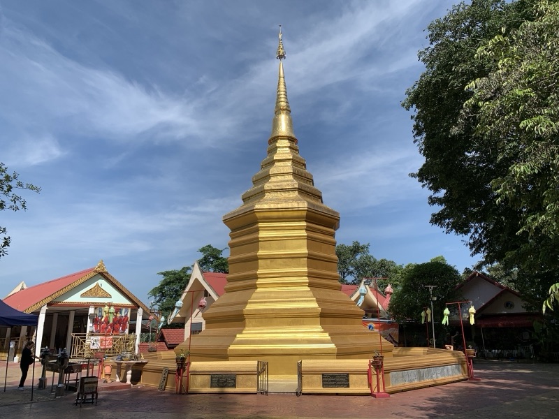
Photo: Chainwit. / Wikimedia Commons (CC BY 4.0)
The 2002 Chiang Rai provincial profile (the copy kept by the Payap University library) suggests that Phra That Chom Thong was built around 940 CE (B.E. 1483), before King Mangrai founded the town. This is a guess; no contemporary evidence confirms it.
When King Mangrai moved to Chiang Mai, Chiang Rai came under Chiang Mai, ruled by his son Khun Khram (Phra Chai Songkhram). The same document says that when Lanna fell under Burmese rule and war followed war, Chiang Rai was abandoned after about 1787, until 1843, in the reign of King Rama III, when it was re-founded as a town under Chiang Mai.
Chiang Saen and Yonok: the old town on the Mekong
Long before Wiang Chiang Rai, the plain of the Kok and the Mekong had stories reaching much further back. The dictionary explains yonok nakhon (โยน฿กฯนคอฯร, yonok nakhon) as Yonok Nakhon, the realm of Yonok, a state of the Tai Yuan on the Kok River plain that grew quickly in the 12th century CE (the 17th Buddhist century). Yonok (โยน฿กฯ, yonok) means the Tai Yuan or Tai Yonok people, who today call themselves Khon Mueang.
The archaeology database of the Sirindhorn Anthropology Centre (compiled by Thanongsak Loetphiphatwarakun) explains that Chiang Saen appears in three main legends: the Suwanna Khom Kham legend, the Singhanavati legend and the legend of Hiran Nakhon Ngoen Yang. These legends reach back to the Buddha's lifetime, but excavations have found nothing older than 1328 CE, the year Phaya Saen Phu founded Chiang Saen on an older site, as a stronghold against the north.
The wide wetland between Mae Chan and Chiang Saen has a legend of its own: it was once a Yonok town that sank in a single night. Read it in Wiang Nong Lom, and the story of the prince who founded Yonok in Singhanavati and the Naga.
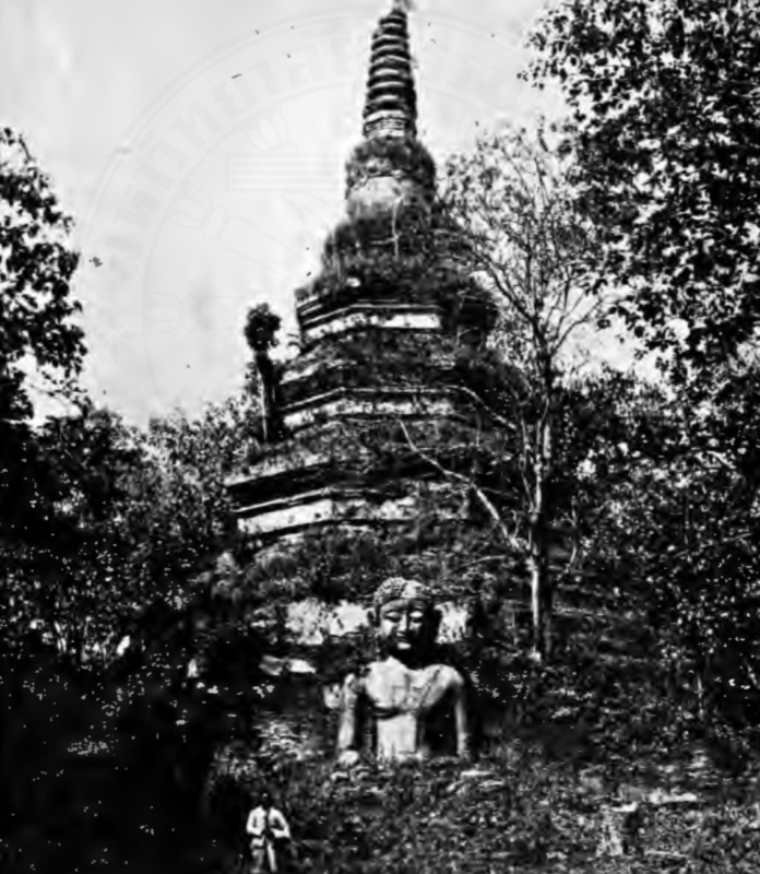
Photo: นารถ โพธิประสาท / Wikimedia Commons (Public domain)
The same database traces the town's path:
| Year | What happened at Chiang Saen |
|---|---|
| 1328 CE | Phaya Saen Phu founds Chiang Saen |
| 1345–1367 | Under Phaya Phayu the centre of power moves back to Chiang Mai; Chiang Saen becomes a second town |
| 1558 | Lanna falls under Burmese rule |
| 1701 | Burma makes Chiang Saen one of its administrative centres; overland trade with China revives the town |
| 1804 | King Rama I sends Siamese armies and Phraya Kawila to take the town back from Burma |
| Reign of King Chulalongkorn (Rama V) | Chao Inthawichai, ruler of Lamphun, goes north to resettle the town |
| 1957 | Chiang Saen becomes a district of Chiang Rai Province |
Today three sides of the Chiang Saen wall remain, north, west and south. No wall is left on the east side along the Mekong; the database suggests the river washed it all away. Inside the town is Wat Phra Chao Lan Thong. Kham Mueang calls such a Buddha image lan tong (ล้านฯทอฯง, lan tong); the dictionary notes there are several, one of them in Chiang Saen district.
The Fine Arts Department's Chiang Saen National Museum keeps the finds from the old town. Watch the department's own introduction to the museum below.

A map of Jiang Hai: old towns, legends and Chiang Rai today
Chiang Rai has old towns and sacred places all over the province. Tap the pins on the map below: each one gives the date, the story, Kham Mueang words from the dictionary and the source. When you have read them all, open the Find it tab and see whether you remember where everything is.
Phra That Doi Tung, the Emerald Buddha and Jiang Hai's old temples
Phra That Doi Tung: the first chedi and the banner on the summit
Kham Mueang calls a chedi a that (ธาฯตฯ, that), and the provincial motto ends with "precious Phra That Doi Tung". An article in the MCU Ubon Ratchathani Journal of Buddhist Studies (2023) summarises the Yonok chronicle: according to the legend, the first chedi was built under King Achutarat of Yonok to enshrine a relic of the Buddha's left collarbone; a second chedi was later built beside it, which is why Doi Tung has twin chedis to this day.
The name Doi Tung comes from the tung (ทุง, tung), which the dictionary defines as a flag or banner. The same article cites Sarassawadee Ongsakul (2009): when the stupa was built, a centipede-shaped banner a thousand wa long was raised on the summit, and wherever its tail blew became the boundary of the stupa's grounds, so the mountain was named Doi Tung. Tellings differ on the banner's length; a source quoted in Tung: Lanna Banners says 3,000 wa.
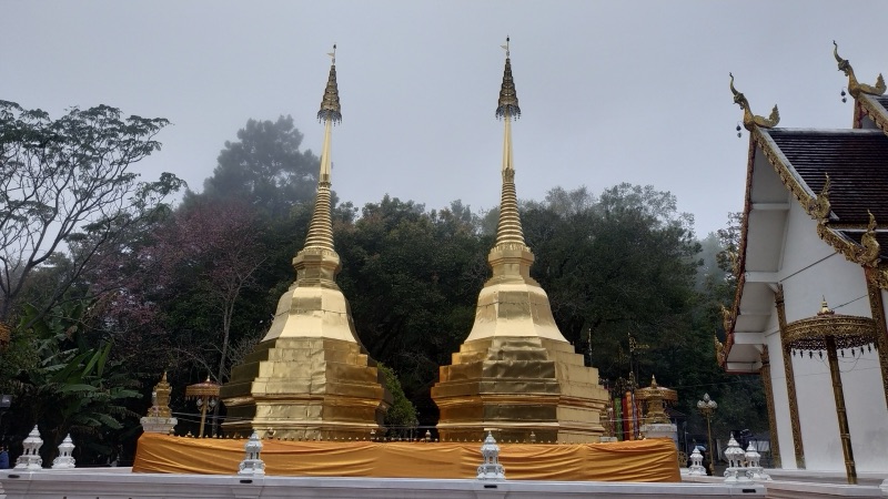
Photo: Xiengyod~commonswiki / Wikimedia Commons (CC BY-SA 4.0)
Phra That Doi Tung is the that pi koet (ธาฯตฯปีเกิดฯ, that pi koet, birth-year stupa) for people born in the Year of the Pig, according to the dictionary's list; see the other years in Lanna Birth-Year Relics. The same journal article says Chiang Rai people hold the festival of worshipping and bathing Phra That Doi Tung on the full moon of the sixth northern month, and that pilgrims come from Chiang Tung, Luang Prabang and Vientiane as well.
Wat Phra Kaew: lightning strikes a chedi and the Emerald Buddha appears
In Chiang Rai town stands Wat Phra Kaew. An article in the Journal of MCU Nakhondhat (2021) says it was once called Wat Pa Yia, after a native bamboo growing there. The story goes that fa pha (ฟ้าผ่า, fa pha, lightning) struck the chedi, and inside was a lacquered and gilded stucco Buddha image; later the plaster flaked off and green stone showed through: the Emerald Buddha. The dictionary defines phra kaeo (ระฯพแก้วฯ, phra kaeo) as a Buddha image made of precious stone, and the temple has been called Wat Phra Kaew ever since.
The year is told two ways. A Silpa Wattanatham article quoting Prince Damrong Rajanubhab and the journal article above give 1434 (B.E. 1977), while the Jinakalamali gives late 1436 (B.E. 1979). The image's later journey, including the elephant that would not walk to Chiang Mai, is told in The Emerald Buddha in Lanna. The same journal notes that the Fine Arts Department registered that chedi as an ancient monument in 1935.
The Golden Triangle, Mae Sai and the Mekong: the border of three lands
The Chiang Rai motto begins "Northernmost in Siam, border of three lands". Kham Mueang words explain both phrases.
In Chiang Saen district the Ruak River flows into the Mekong. Kham Mueang calls a place where two or more rivers meet a sop (ส฿ปฯ, sop), so this point is Sop Luak (ส฿ปฯรวฯก, sop luak). The dictionary places it about 9 kilometres north of the Chiang Saen district office along the Mekong road, where the lands of Thailand, Myanmar and Laos meet, the spot known as the Golden Triangle. The cover photo of this article was taken there.
"Northernmost in Siam", the dictionary notes under Jiang Hai, is the permanent border crossing on the bridge over the Sai River in Mae Sai district, linking to the Tachileik checkpoint in Shan State. A bridge in Kham Mueang is a khua (ข฿วฯ, khua). Under Jiang Tung (ชยฯงตุง, jiang tung) the dictionary adds that the road from the Mae Sai crossing to Chiang Tung (Kengtung) is about 160 kilometres, and that the Tai Khün language used in Chiang Tung has a script much like the Lanna script.
The Mekong flows past Chiang Saen, Chiang Khong and Wiang Kaen; the 2002 provincial profile gives about 94 kilometres of the river within the province. It is home to the pa buek (ปลฯาบึกฯ, pa buek), which the dictionary describes as the world's largest scaleless freshwater fish, found only in the Mekong and its tributaries.
The people of Jiang Hai: Khon Mueang, Tai Lue and the peoples of the highlands
Chiang Rai is home to many peoples. A study by Ranida Pingmuang and colleagues (2017) at Chiang Rai Rajabhat University looked at the food of nine ethnic groups in the Kok and Mekong basins of the province: Tai Yuan, Tai Lue, Tai Yai (Shan), Mien, Pgaz K'nyau (Karen), Akha, Lisu, Lahu and Lao. These are the groups the study chose, not a count of the whole province.
Most local people are Tai Yuan (ไทยวฯร, tai yuan), whom the dictionary describes as the Thai of the eight northern provinces who call themselves Khon Mueang. The Tai Yai (Shan), the dictionary records, call themselves Tai (ไท, tai), and live in Chiang Rai as well.
The Tai Lue of Chiang Khong
The dictionary describes the jao tai lue (ชาวฯไทลื้, jao tai lue) as the Tai Lue, a people of Sipsong Panna with their own spoken and written language. An article by Wichulada Matonboon (2018) in the Journal of Cultural Approach explains that the Tai Lue came into the North by several routes, via Mae Sai and from Laos via Chiang Khong and Wiang Kaen. Chiang Khong district therefore has many Tai Lue, most of them in Si Don Chai subdistrict and then Ban Hat Bai.
The skirts of Tai Lue women in Chiang Khong have signature patterns: lai nam lai (ลายฯนาฯไหลฯ, lai nam lai), which the dictionary describes as a "flowing water" pattern woven by the ko or luang technique, and lai pi, the dragonfly pattern. The same article notes that patterns are mixed more and more today, so the group's own designs are becoming rare. Read about the Tai peoples, with a map, in The Tai Peoples.
The peoples of the highlands
On Chiang Rai's mountains live Akha, Lahu, Lisu, Mien and Pgaz K'nyau communities (the groups in the study above), each with its own language, dress and customs. The dictionary records that the Akha, who call themselves "Akha", came from Yunnan in China, settled in Thailand around 1903, and are most numerous in Chiang Rai Province.
New temples: Chiang Rai's Buddhist art today
Many visitors know Chiang Rai through its newly built temples. A study by Phramaha Setthasiri Pabhassaro and colleagues (2021) looked at ten Buddhist learning sites in Chiang Rai and found two kinds: old temples with long religious importance that later became tourist sites, such as Wat Phra Kaew, Wat Phra Sing and Phra That Doi Tung; and contemporary temples built in an age when a temple is both a place of practice and a place to visit.
- Wat Rong Khun in Mueang Chiang Rai district has a white ordination hall that Chalermchai Kositpipat began building in 1997. The same study explains that the white stands for the Buddha's purity, and the mirror glass for his wisdom.
- Wat Rong Suea Ten on the Kok River was an abandoned temple restored in 1996. Its blue vihara was designed and built by Puttha Kabkaew, a local Chiang Rai artist, in 2005–2006. The name comes from a story that a tiger once leapt across a ditch (rong) in the village.
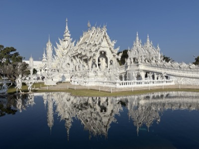
Photo: Chainwit. / Wikimedia Commons (CC BY 4.0)
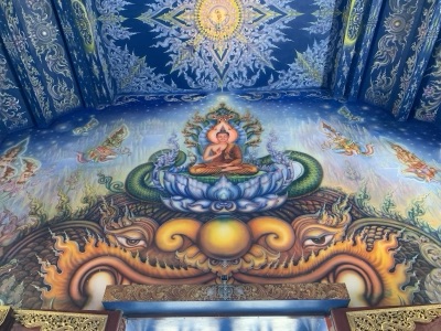
Photo: Chainwit. / Wikimedia Commons (CC BY-SA 4.0)
These temples are new, but they are still temples, not just photo spots. Modest dress and quiet behaviour inside the ordination hall matter as much as in an old temple; see Lanna Temple Etiquette.
Food and specialities of Jiang Hai
The Northern dish everyone in Lanna knows is khao soi (เขั้าซอฯยฯ, khao soi), which the dictionary describes as noodles in a rich, spicy coconut curry, eaten with pickled mustard greens, shallots and lime; for a Khon Mueang way to cook it, see Khao Soi Gai. The study by Ranida Pingmuang and colleagues (2017) collected as many as 74 recipes from the nine ethnic groups of Chiang Rai.
A Department of Intellectual Property presentation (2019) lists Chiang Rai's geographical indication (GI) products:
| GI product | Related Kham Mueang |
|---|---|
| Chiang Rai tea | — |
| Doi Tung coffee · Doi Chang coffee | — |
| Nang Lae pineapple · Phu Lae pineapple | ba khanat (บ่าฯขหันฯด, pineapple) |
| Lanna purple rice (khao kam) | khao kam (เขั้ากํา, black sticky rice) |
| Wiang Kalong ceramics | application then under review |
The dictionary also lists kuai jiang hai (ก้ลฯวฯยฯชยฯงรายฯ, kuai jiang hai), a banana that originated in Sipsong Panna and is grown in Chiang Rai, fragrant and sweet, with smaller fruit than the common nam wa banana.
Wiang Kalong in Wiang Pa Pao district is an old Lanna ceramic kiln site. A study by Penrung Suriyakan (2010) of the Faculty of Archaeology, Silpakorn University, tells how villagers once dug up old wares to sell, then turned to protecting the kilns on their own land and making new Wiang Kalong ceramics instead.
The Chiang Rai motto and the kasalong kham
The dictionary records the provincial motto under Jiang Hai:
Motto: "Northernmost in Siam, border of three lands, home of Lanna culture, precious Phra That Doi Tung"
| Line of the motto | What it refers to |
|---|---|
| Northernmost in Siam | The border crossing on the Sai River bridge, the country's northern tip |
| Border of three lands | Sop Luak, the Golden Triangle, where Thailand, Myanmar and Laos meet |
| Home of Lanna culture | King Mangrai's first city and the culture of many peoples |
| Precious Phra That Doi Tung | The twin chedis on Doi Tung, birth-year stupa for the Year of the Pig |
The provincial tree is the pip thong (ปีปฯทอฯง, pip thong, golden trumpet tree), which Khon Mueang call kasalong kham (กาสะลอฯงฅำ, kasalong kham). The dictionary describes a medium-sized tree 10 to 25 metres tall, with long tubular orange-yellow flowers in small clusters of three or four along the branches and trunk, and dry sword-like pods up to 45 centimetres long.
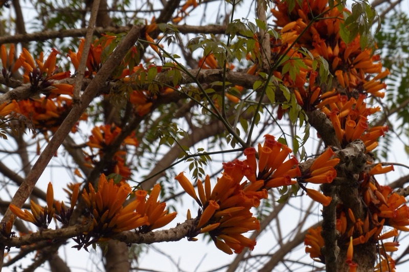
Photo: Trevalb / Wikimedia Commons (CC BY 4.0)
The name kasalong kham sounds like dok kasalong (ดอฯกกาสลอฯง, dok kasalong), the Indian cork tree flower that smells strongly at night. Kham in Kham Mueang means gold, so the name matches pip thong, "golden pip", exactly. The Chiang Rai Provincial Comptroller's Office also lists a provincial flower, the orange trumpet vine (dok phuang saet). See the trees of all eight Lanna provinces in The Eight Lanna Provinces, and more flower names in Lanna Flowers.
Visit Jiang Hai like a Khon Mueang
To go out and enjoy yourself in Kham Mueang is pai aeo (ไพแอ่วฯ, pai aeo). The phrases below are built from dictionary words and work at the market, at a temple and when chatting with people in Chiang Rai.
| Kham Mueang | Reading | Meaning |
|---|---|---|
| ไปแอ่วเจียงฮาย | pai aeo jiang hai | to visit Chiang Rai |
| ไปตางใดมา (ไพทาฯงฯไดมา) | pai tang dai ma | Where have you been? (a greeting) |
| กิ๋น (กินฯ) เข้าซอย ลำแต๊ (ลำแท้) | kin khao soi, lam tae | I'm eating khao soi, it's really delicious |
| บ่าขะหนั๋ด เต้าใด (เทัาฯฯได) | ba khanat tao dai | How much is the pineapple? |
| ยินดี (ยินฯดี) เจ้า (เจั้า) | yin di jao | Thank you (polite) |
Summary
- Jiang Hai is Chiang Rai in Kham Mueang. Jiang means city, and the name shows two sound rules at once: ch becomes j and r becomes h.
- King Mangrai (Kham Mueang reading mang lai) founded the town in 1262; legend says he followed a lost jang (elephant) to Doi Chom Thong on the Kok River. The town was re-founded in 1843.
- Chiang Saen was founded by Phaya Saen Phu in 1328. The Yonok legends reach further back, but archaeology has found nothing older.
- Phra That Doi Tung takes its name from the tung banner of the legend and is the birth-year stupa for the Year of the Pig; Sop Luak is the Golden Triangle, where three countries meet.
- Chiang Rai is home to the Khon Mueang, the jao tai lue, the Tai and many highland peoples; its provincial tree is the kasalong kham.
Look up more Chiang Rai words in the Moradok Lanna dictionary, and read about the city King Mangrai built after Jiang Hai in Chiang Mai (Jiang Mai).
📚 The whole series: see the provinces, old cities and peoples on one map in Places of Lanna: 8 Provinces, Old Cities and Peoples
Sources
- Moradok Lanna dictionary (in Thai): เจียงฮาย · เจียง · มังราย · โยนกหนะกอน · ส๋บลวก · ตุง · ธาตุปีเกิด · จาวไตลื้อ · ก๋าสะลองคำ · แมงสี่หูห้าตา
- สำนักงานคลังจังหวัดเชียงราย (Chiang Rai Provincial Comptroller's Office). ประวัติความเป็นมาของศูนย์ข้อมูลข่าวสาร และประวัติจังหวัดเชียงราย [Information centre and history of Chiang Rai Province]. Official Information Centre
- ทนงศักดิ์ เลิศพิพัฒน์วรกุล (database editor). เมืองเชียงแสน [Chiang Saen] and วัดเจดีย์หลวง (เชียงแสน) [Wat Chedi Luang, Chiang Saen]. Database of important archaeological sites in Thailand, Princess Maha Chakri Sirindhorn Anthropology Centre
- พระมหาสงกรานต์ จิรวฑฺฒโน and สมคิด เศษวงศ์. (2023). การส่งเสริมประเพณีสรงน้ำพระธาตุดอยตุง จังหวัดเชียงราย [Promoting the tradition of bathing Phra That Doi Tung, Chiang Rai]. MCU Ubon Ratchathani Journal of Buddhist Studies 5(2) (citing Sarassawadee Ongsakul 2009)
- พระมหาเศรษฐศิริ ปภสฺสโร, วิโรจน์ วิชัย and พิสิฏฐ์ โคตรสุโพธิ์. (2021). กระบวนการสร้างอัตลักษณ์ของแหล่งท่องเที่ยวเชิงพุทธในเชียงราย [The process of identity construction of Buddhist tourist sites in Chiang Rai]. Journal of MCU Nakhondhat 8(1), 175–187
- ปดิวลดา บวรศักดิ์. (2026). "ตำนานพระแก้วมรกต" จากพระนิพนธ์ "สมเด็จฯ กรมพระยาดำรงฯ" [The legend of the Emerald Buddha, from Prince Damrong's writing]. Silpa Wattanatham
- วิชุลดา มาตันบุญ (Wichulada Matonboon). (2018). การอนุรักษ์ สืบสาน และการดำรงอยู่ของภูมิปัญญาด้านการทอผ้าของชาติพันธุ์ไทลื้อ อำเภอเชียงของ จังหวัดเชียงราย [Conserving and continuing Tai Lue weaving wisdom in Chiang Khong, Chiang Rai]. Journal of Cultural Approach 19(35), 89–96
- รณิดา ปิงเมือง et al. (2017). ความหลากหลายทางชีวภาพสู่ความมั่นคงทางอาหารของชาติพันธุ์ในลุ่มน้ำกก-ลุ่มน้ำโขง: กรณีศึกษา จังหวัดเชียงราย [Biodiversity and food security of ethnic groups in the Kok and Mekong basins, Chiang Rai]. Journal of Social Sciences, Chiang Rai Rajabhat University 10(2)
- Department of Intellectual Property. (2019). GI Thailand (presentation)
- Penrung Suriyakan. (2010). Wiang Kalong Ceramic Artisans: From Looters to Conservationists. Damrong Journal 9(2)
- ปาริสุทธิ์ สีทองดี (compiler). การกลายเป็นเมืองของเมืองเชียงราย [The urbanisation of Chiang Rai]. Thailand Environment Institute
- Payap University Library. (2002). จังหวัดเชียงราย [Chiang Rai Province] (copied from the Chiang Rai provincial website)
- Video: Fine Arts Department. พิพิธภัณฑสถานแห่งชาติ เชียงแสน [Chiang Saen National Museum]. YouTube
- Map in the widget: province lines and rivers © OpenStreetMap contributors (ODbL), via geoBoundaries
- All images from Wikimedia Commons, credited under each picture
Practise the words from this article
Flip through 39 flashcards of the Lanna words used in this article.
Look up "เจียงฮาย" in the Moradok Lanna dictionary (in Thai)


