
Photo: Iudexvivorum / Wikimedia Commons (CC0)
Wiang Kum Kam: Did a City Really Drown?
Wiang Kum Kam is the town King Mangrai built on the Ping River before he founded Chiang Mai. Today it lies in Tha Wang Tan, Saraphi district, about 5 km south of Chiang Mai. Most of us hear its story in one line: "floods drowned the town, so Mangrai moved and built Chiang Mai", and some call it the underground city or the Atlantis of Lanna. Kham Mueang has a word for a town nobody lives in any more, mueang hang (เมิอฯงห่างฯ), and Wiang Kum Kam really was a mueang hang for several centuries, just not in the way the story says.
This article is part of the Fact or Tale series. We do not rule for the reader. We take the story of Wiang Kum Kam apart and show which pieces have evidence from digs, inscriptions or geology, which are only in the chronicles written down centuries later, which were added later by news and tourism, and which are still open because scholars disagree.
The cover photo shows Wat Ku Pa Dom. Its brick base sits about a metre and a half below the surrounding ground: that is the depth of sand the archaeologists had to dig away before the temple appeared.
Wiang Kum Kam in the chronicles: Mangrai's riverside town
The founding of Wiang Kum Kam is told in several of the texts northern Thais call tamnan (ตํานาฯ), chronicles: the Chiang Mai Chronicle, the Mulasasana, the Fifteen Dynasties chronicle, the Jinakalamali and the Yonok Chronicle. All agree that King Mangrai (มังฯรายฯ, read Mang-lai) built it after taking Hariphunchai, the town Kham Mueang calls Lapun (หลฯะพูร) (SAC archaeology database; Sahawat et al.).
The Yonok Chronicle says that in CS 648 Mangrai moved to build a town near the Ping and "had a moat dug on all four sides, letting the Ping's water fill it, and raised a wall all round". He had a pond dug near the palace, and because he looked out of a window (tang) every day to watch the work, it was called Nong Tang. Then he set up the Kum Kam market, a kat (กาดฯ) in Kham Mueang.
The best-remembered scene has Mangrai dressed as a commoner, sitting by the river to watch people come to market. He saw people crossing to the market until "the boats were so crowded that several capsized each day", so he had "a bridge built across the river, called the Kum Kam bridge from then on" (Yonok Chronicle, Prachum Phongsawadan part 5). A boat is huea (เริอฯอ) and a bridge khua (ข฿วฯ) in Kham Mueang. The Fine Arts Department's Chiang Mai office quotes the same story from the Chiang Mai Chronicle.
The chronicles also say Mangrai had earth from Nong Tang made into bricks for a ku (กู่), a stupa, called Ku Kham, which is today's Wat Chedi Liam, and built a monastery for five monks who stayed under a great fig tree, with five Buddha images cast for it. The Fifteen Dynasties chronicle names the craftsman Kan Thom, hence the temple's name Wat Kan Thom, now Wat Chang Kham (Fine Arts Department, Office 7).
Keep in mind that these chronicles were written down or copied much later. The printed Chiang Mai Chronicle, for example, comes from a Wat Phra Ngam manuscript inscribed in 1854 (Sahawat et al.). The market, the capsizing boats and the bridge paint a busy riverside town, but no bridge remains or other evidence confirm the details.
Before Mangrai: a Hariphunchai community under Wat Kan Thom
Wiang Kum Kam came back into wide view in 1984, when the Fine Arts Department dug at Wat Kan Thom (Wat Chang Kham) and found terracotta votive tablets in the Hariphunchai style. Digging went on in phases for about 20 years, until 2003 (Sahawat et al.; Chiang Mai News).
The dig at Wat Kan Thom showed what the chronicles only hint at. The Sirindhorn Anthropology Centre's archaeology database sums up that under the Kan Thom hall lies an older building, with a stone inscription in Mon script and Hariphunchai-style objects, above all terracotta tablets: a small Hariphunchai-culture community lived here from around the 12th–13th century, before Mangrai came. The Fine Arts dig team reached the same conclusion: "Mangrai built Wiang Kum Kam in an area of Hariphunchai-culture community".
The chronicles themselves say a great fig tree stood there, honoured by the people before the monks came. Researchers at the Fine Arts Chiang Mai office read this as Mangrai blending local beliefs with Buddhism. That is an interpretation, not something dug up.
A town still alive after Chiang Mai was built
Mangrai founded Chiang Mai (ชยฯงไห่มฯ, Jiang Mai in Kham Mueang) in 1296, but Wiang Kum Kam was not abandoned with it. The SAC database concludes from the digs that after Mangrai moved, Wiang Kum Kam remained an important town, "not left abandoned even after the great flood, because building and repairs continued inside Wiang Kum Kam until the 23rd Buddhist century".
The written record points the same way.
| When | Evidence | Source |
|---|---|---|
| c. 1370 | The Wat Phra Yuen inscription (Lamphun) names people "living in Kum Kam and Chiang Mai" who came to honour the monk Sumana | SAC database; Sahawat et al. |
| after 1411 / 1455 | Townspeople build a flood embankment (see below) | Ng et al.; Sahawat et al. |
| 1517–1523 | Under King Mueang Kaeo: rites at Wat Ko Kum Kam, a bronze image installed at Wat Kum Kam Thiparam, a large hall built at Wat Ku Kham | Sahawat et al. (from the Jinakalamali); SAC database |
| c. 1517 | The court poet of Nirat Hariphunchai still describes Wiang Kum Kam on the old course of the Ping, and mentions Ku Kham | Monwat Promrat (2025); Saritpong Khunsong (2006) |
So Monwat Promrat (2025) argues that what Mangrai met at Wiang Kum Kam was most likely the seasonal floods he had known at his earlier towns, not floods that made the town unliveable. Kham Mueang calls such water nam nong (นาฯนอฯง), which the dictionary explains as flood water, water rushing in.
Digging down: what the layers say
The Fine Arts dig team sorts the soil over the Wiang Kum Kam ruins into three groups (Sahawat et al.):
- Topsoil: brown sandy loam with scattered finds, formed after the great flood and used by people up to today.
- Ping river sand: fine to coarse sand; at some sites, such as Wat E-Kang, mixed with large gravel.
- The layer below the sand: grey-brown sandy loam with finds, the ground people used for temples and houses until the great flood.
Sand is sai (ซายฯ) in Kham Mueang, and sediment that settles to the bottom is khamun (ขมุ่ร). The geologists Serene Ng, Spencer Wood and Alan Ziegler (2015) studied the floodplain layers here and also found a coarse sand layer from one great flood; they conclude the town was abandoned after it.
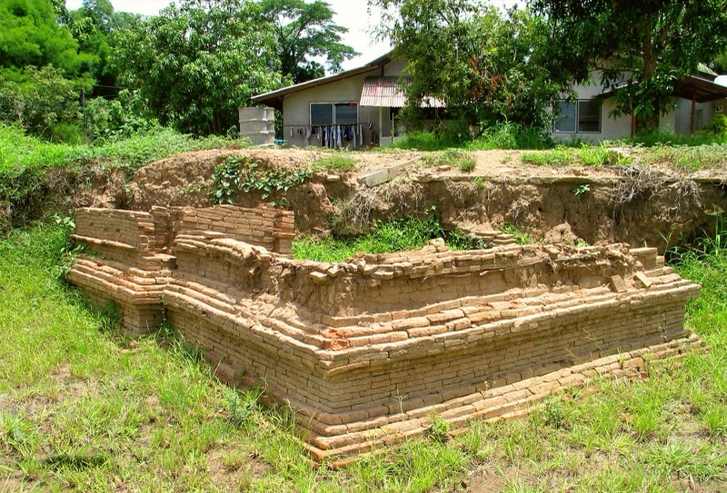
The sand is not equally thick everywhere. At Wat Nan Chang, Wat Ku Pa Dom and Wat Bot, towards the west of the town, it is about 1.5 m deep; at other sites only 0.5–1 m. The dig team suggests those temples "may have been used after the great flood" (Sahawat et al.). A Wiang Kum Kam guide interviewed by MGR Online (2011) adds that Chedi Liam is the only monument the silt never covered.
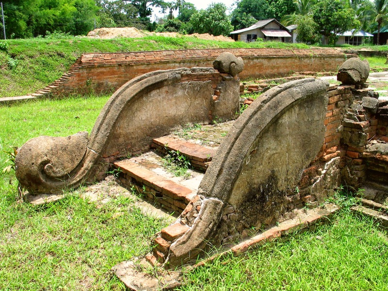
Two remarkable things lay under the sand. In late 2003, at Wat Ku Pa Dom, the dig found a low-relief stucco Chinese-style dragon emerging from a makara's mouth on the ordination hall's stair rail, which the team calls the first of its kind in Lanna art. At Wat Nan Chang it found a jar hidden beneath the sand, sealed with a bronze tray and bricks and holding Chinese wares; one dish bears the Wanli reign mark of the Ming dynasty (1573–1619) (Sahawat et al.; Chiang Mai News).
Pick a site and dig down one layer at a time. Every layer names its sources.
When did the sand come? Five answers that do not match
Everyone agrees that a great flood brought the sand over the town; a flood is nam thuam (นาฯถ้วฯม) in Kham Mueang. Nobody can yet say which year it came.
| Who | What they say | Based on |
|---|---|---|
| Geologists Ng et al. (2015) | The sand came after about 1477–1512, and the town was abandoned after this flood | radiocarbon dates of charcoal in the coarse sand |
| Monwat Promrat (2025) | Floods that made the town unliveable came no earlier than about the mid-16th century | a poet of 1517 still describes the town on the old Ping |
| Fine Arts dig team (Sahawat et al.) | The sand came after 1573, perhaps the great flood the chronicles record in 1657 | the jar with the Wanli dish was buried before the sand |
| SAC database | The town was used into the 23rd Buddhist century (about 1658–1757), then lay empty for a while | documents and digs |
| The popular telling | Floods forced Mangrai to move (1290s) | retelling; no evidence says so |
A word of care: a charcoal date only says the sand came after that charcoal formed, not the year of the flood. As for the 1657 flood, the Yonok Chronicle has only one short line, "in CS 1019 ... floods from the north covered every town", without naming Kum Kam. The dig team itself says more sites must be dug.
These views do not clash everywhere. The first three agree that the sand came centuries after Mangrai; they differ on the exact span. The popular telling, which ties the flood to the move to Chiang Mai, matches no piece of evidence.
On the widget's second tab, tap each view to see the span it proposes. Tap "The popular telling" and the green-ringed dots show the evidence that people still lived here after 1296.
The dyke: how the people of Kum Kam fought the water
If the people of Wiang Kum Kam lived with floods for generations, they should have left traces of it, and they did. Ng et al. (2015) found that a long mound on the town's floodplain is a dyke built after about 1411 to ease the repeated floods, floods the Chiang Mai Chronicle records and the sediments also show.
The Fine Arts dig team found a north–south embankment east of Wat Phra Chao Ong Dam, Wat Phaya Mangrai and Wat Nan Chang. Under it lay clay cores of crowned Buddha images, which Sakchai Saisingha's work dates in Lanna to King Tilokarat's time, so the team suggests the embankment was built after 1455 "as a levee against the overflow of the Ping Hang". The two studies use different methods and give different years, but both show the townspeople building flood defences while the town was alive.
Besides dykes, Lanna had mueang (เหิอฯง) irrigation channels dug to carry water to the fields. Monwat (2025) points out that the Chiang Mai–Lamphun basin had many such channels linked to old river courses from before Chiang Mai was founded.
Ping Hang: the old river, or a dug channel?
In Wiang Kum Kam runs a shallow channel that site signs call Ping Hang, the old, abandoned course of the Ping. The dictionary gives hang (ห่างฯ) the sense of deserted, abandoned, as in wat hang (วัดฯห่างฯ), an abandoned temple. So Ping Hang means, word for word, the deserted Ping.
But is the channel really the old Ping? That is still open.
- The SAC database says Wiang Kum Kam ran along the old Ping, called Ping Hang, until the river changed course and left the town on the east bank of today's Ping. The Fine Arts Chiang Mai office adds that 1954 aerial photos show the town lying along the old course.
- The Fine Arts dig team reports that a preliminary sediment study of the channel believed to be the old Ping "found it to be only a channel dug to draw water", with results still to be presented.
- The geologists Elisha Teo et al. (2018) note that the Wiang Kum Kam excavation is the one place where a sudden course change of the Ping has been scientifically confirmed, and that the Ping has moved westwards across the Chiang Mai basin.
So the Ping did change course here, but whether the channel the signs point to is that old river or a later irrigation channel still awaits the study.
Silence in the records, then people return
After the Burmese took Chiang Mai in 1558, the name Wiang Kum Kam slowly fades from the local records. The dig team notes that a list of towns in turmoil around 1759, detailed down to small villages, does not name Kum Kam at all, and concludes that "Kum Kam no longer appears as a town from the start of the 24th Buddhist century". The SAC database also suggests the town may have stood empty then. For this period see Lanna Under Burmese Rule.
Yet the name never left people's memory. The Chiang Mai chronicle, telling of King Taksin's time, places Pa Sang "a day's journey from Kum Kam", and records from the early years of King Kawila mention Tha Wang Tan, a river landing inside the old town; the dig team reads this as people coming back (Sahawat et al.; SAC database).
Under Rama V more people settled here and some temples were restored. Under Rama VI land titles were issued, so many ruins ended up on private land, one reason the digging took so long (Sahawat et al.).
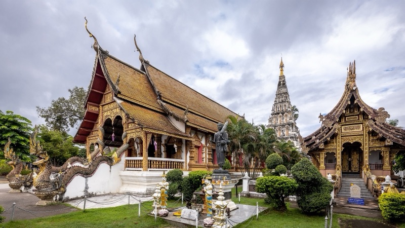
Chedi Liam is a good example. Saritpong Khunsong (2006) explains that this stupa, believed to be Mangrai's, was heavily restored nearly a hundred years before his article by Luang Yonakan Wichit, a Mon merchant of Burmese nationality, who changed almost all the original detail into Burmese style and added large Buddha niches in the middle of all four sides of the base. The Fine Arts dig team also dates the restoration to the reign of Rama V. The stupa standing here is Mangrai-era in structure, but its look is later work.
The underground city: a new kind of story
Once digging began, Wiang Kum Kam got new names. MGR Online (2011) and THE STANDARD (2022) call it the "underground city", and Ng et al. (2015) quote the name "Atlantis of Lanna". Travel news and websites often call it "the first capital of Lanna" (Chiang Mai News; SAC community wiki), though the dictionary records that Mangrai built Chiang Rai earlier, in 1262. Such names draw visitors, but they also suggest a whole city sinking at once, which is not what the evidence shows.
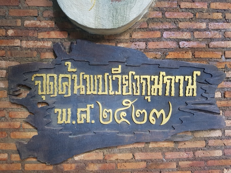
The sign "Wiang Kum Kam discovery point, 1984" at Wat Chang Kham belongs to this new telling too. The chronicles never forgot Wiang Kum Kam; what began in 1984 was systematic excavation, which let us see the town under the sand more clearly. For another real place that a later story made famous, the pool above Huai Kaeo Falls, see Wang Bua Ban.
Wiang Kum Kam still lives with water. Many ruins were dug more than a metre below the surface, so they hold water every rainy season. In 2011 residents worried that water standing for a month or two would damage the ruins; in 2022 about 20 sites were flooded and the department pumped slowly so the bricks could adjust; and in late 2024 floodwater stood more than 2 m deep at Wat Ku Pa Dom for nearly a month, with the stucco dragon under water (MGR Online; THE STANDARD; Daily News). The earthquake of 28 March 2025 cracked Chedi Liam, loosened its plaster and brought down its north-west corner stupa (Daily News; Thai Post).
The map on the widget's third tab shows which temples are named in the chronicles, which are known only from digging, and where the channel the signs call Ping Hang runs.
Piece by piece: record, story or later telling
Sort 15 pieces of the Wiang Kum Kam story into the boxes yourself, then see how the story grew from the chronicles to the geology. Press "Compare" on two versions to set them side by side.
Common misunderstandings: what the sources show
"Mangrai abandoned Wiang Kum Kam because floods drowned it"
The sources do not say that. People went on living and building here for centuries after Mangrai moved to Chiang Mai: the Wat Phra Yuen inscription, the flood dyke, the works of King Mueang Kaeo. The sand that buried the town came much later. Why Mangrai chose Chiang Mai's site is in King Mangrai and Chiang Mai, Jiang Mai.
"The whole city sank underground at once"
The sand is not even: about 1.5 m at some temples, only half a metre to a metre at others, and Chedi Liam was never covered. The dig team even suggests some temples stayed in use after the great flood. Another town the legend says sank in one night is Yonok, where legend and geology also tell different stories: Wiang Nong Lom: Did a City Really Sink?
"Nobody knew about Wiang Kum Kam until 1984"
The chronicles always named it, Kum Kam was still a landmark in Kawila's time, and Chedi Liam was restored under Rama V. 1984 is the year systematic digging began.
"The Ping Hang channel is certainly the old Ping"
Not yet certain. The Ping did change course here, but a preliminary Fine Arts sediment study found the visible channel may be a dug water channel.
"Wiang Kum Kam was certainly built in 1286"
That is the year most chronicles give, but the older Jinakalamali gives 1303 and 1294 has been proposed. Scholars have not settled it.
Summary
- Wiang Kum Kam is real: every chronicle credits Mangrai, the rectangular town of about 600 × 850 m shows on aerial photos, and digs since 1984 have uncovered more than 20 temples.
- A Hariphunchai-culture community lived here before Mangrai came.
- The market, the capsizing boats and the Kum Kam bridge are only in the chronicles, and the founding year is still disputed.
- The town lived on for centuries after Chiang Mai was built. Ping river sand buried it much later, but geologists, historians and the dig team still differ on when.
- "Underground city", "first capital" and "moved because of floods" are later tellings, not what the evidence shows.
Look up more words from this story: เมืองห่าง น้ำถ้วม ห่าง น้ำนอง
📚 The whole Lanna story: Lanna: Where the Name Comes From, and 700 Years of the Land · The founder: King Mangrai · The town he built next: Chiang Mai, Jiang Mai
Lanna stories people still half-believe, taken apart into what is on record, what one teller or text first said, and what was added later.
1. Ma Mia: What's Real, What's Legend, What's Fiction · the Royal Gazette, the 1964 book Phet Lanna and Charan's song: what is on record and what was added later
2. Wang Bua Ban: What's Real, What's Told, What's Tale · the teacher's legend above Huai Kaeo Falls: six tellers, a song, a film and the family's own account
3. Sao Khruea Fa: A True Northern Story or Madame Butterfly? · Prince Narathip's sung play adapted from Madame Butterfly, and why people took it for a true northern story
4. Wiang Nong Lom: Did a City Really Sink? · the chronicle's town that sank in one night, set against the Mae Chan fault, archaeology and measured quakes
▸ 5. Wiang Kum Kam: Did a City Really Drown? (you are here) · King Mangrai's town under the Ping river sand: the Fine Arts digs and the open question of when the sand came
6. Lilit Phra Lo: Real, Legend or Fiction? · Sarong, Wiang Lo and the Kalong river: what the poem says, and how later readers placed its towns on a real map
Sources
- Moradok Lanna dictionary: เมืองห่าง · น้ำถ้วม · ห่าง · วัดห่าง · น้ำนอง · ซาย · ขะมุ่น · กาด · ขัว · เฮือ · กู่ · เหมือง
- ชัยวัฒน์ ศิริซุ้มสุวรรณ (ed.). เวียงกุมกาม [Wiang Kum Kam]. Archaeological Sites Database, Sirindhorn Anthropology Centre (citing Fine Arts Department 1991, 2005; Jirasak Dechwongya 2005; Sarassawadee Ongsakul 1994)
- สหวัฒน์ แน่นหนา, ทรรศนะ โดยอาษา, วิวรรณ แสงจันทร์. เวียงกุมกาม: เมืองโบราณใต้ตะกอนทราย [Wiang Kum Kam: the ancient town under the sand]. Silpa Wattanatham (online 9 April 2017)
- สำนักศิลปากรที่ ๗ เชียงใหม่. กำเนิดเวียงกุมกาม [The birth of Wiang Kum Kam]. Fine Arts Department
- พระยาประชากิจกรจักร์. พงษาวดารโยนก [Yonok Chronicle]. In Prachum Phongsawadan part 5 (1917). Wikisource
- พงษาวดารเมืองนครเชียงใหม่ เมืองนครลำปาง เมืองลำพูนไชย [Chronicle of Chiang Mai, Lampang and Lamphun]. In Prachum Phongsawadan part 3 (1914). Wikisource
- Ng, S., Wood, S. H., & Ziegler, A. D. (2015). Ancient Floods, Modern Hazards: The Ping River, Paleofloods and the 'Lost City' of Wiang Kum Kam. Natural Hazards 75(3), 2247–2263. doi:10.1007/s11069-014-1426-7
- Teo, E. A., Ziegler, A. D., Wasson, R. J., & Morthekai, P. (2018). Locating and Dating the Ping River's Journey Across the Chiang Mai Basin, Thailand. EGU General Assembly, abstract EGU2018-3911
- มนวัธน์ พรหมรัตน์. (2025). มองเชียงใหม่ใหม่: พญามังราย อำนาจ กับภูมิอากาศโลก [Chiang Mai anew: Mangrai, power and global climate]. Payap University Journal 35(2)
- สฤษดิ์พงศ์ ขุนทรง (Saritpong Khunsong). (2006). ข้อคิดเห็นเกี่ยวกับพระพุทธรูปประดิษฐานในจระนำซุ้มที่ฐานเจดีย์เหลี่ยม เวียงกุมกาม [Niches at the base of Chedi Liem, Wieng Kum-Kam]. Damrong Journal
- เชียงใหม่นิวส์. “เวียงกุมกาม” จากความรุ่งเรืองสู่การค้นพบใหม่ [Wiang Kum Kam: from glory to rediscovery]. Chiang Mai News
- Sirindhorn Anthropology Centre. เวียงกุมกาม [Wiang Kum Kam]. Community Wiki
- MGR Online. (27 September 2011). “เวียง กุมกาม” นครใต้พิภพ วันที่ร่องรอยประวัติศาสตร์จมน้ำ [Wiang Kum Kam, the underground city, under water]
- THE STANDARD. (6 October 2022). โบราณสถานเวียงกุมกาม ๒๐ แห่ง ถูกน้ำท่วมขัง [20 Wiang Kum Kam sites flooded]
- Daily News. (28 October 2024). กรมศิลป์เร่งกู้ 'มังกรกู่ป้าด้อม' ศิลปกรรมหนึ่งเดียวในล้านนา หลังน้ำท่วมจมนับเดือน [Fine Arts Department rescues the Ku Pa Dom dragon after a month under water]
- Daily News. (5 April 2025). 'สุดาวรรณ' มอบกรมศิลป์เร่งบูรณะ 'โบราณสถานวัดอุโมงค์' หลังแผ่นดินไหว [Culture minister orders repairs after the earthquake]
- Thai Post. (6 April 2025). วัดเจดีย์หลวง-วัดอุโมงค์แตกร้าว เร่งเสริมความแข็งแรง [Cracks at Wat Chedi Luang and Wat Umong; repairs]
- Naewna. (2026). คอลัมน์ มองอย่างไท [column Mong Yang Thai] (an example of the "moved because of floods" telling)
- OpenStreetMap contributors. The channel site signs call the old Ping (ODbL; used in the widget map)
Practise the words from this article
Flip through 18 flashcards of the Lanna words used in this article.
Look up "เมืองห่าง" in the Moradok Lanna dictionary (in Thai)


